")


A winter storm packing ice and snow arrives Friday across the Great Lakes and the Northeast and is forecast to linger into Saturday.
It will bring ice, sleet and freezing rain from the Upper Midwest to the Mid-Atlantic, while significant amounts of snow will accumulate across parts of New York — potentially the most snowfall New York City has seen in years.
Map shows winter storm alerts
Millions of Americans live in areas under winter storm alerts stretching from northern Minnesota to the Eastern Seaboard.
CBS News
Winter storm warnings are in effect from Friday afternoon through midday Saturday for New York City and surrounding areas, including northern New Jersey, most of Long Island, the Hudson Valley and western Connecticut.
An ice storm warning is in effect through Saturday morning in the central Pennsylvania counties of Somerset, Westmoreland (ridges), Indiana, Armstrong, Clarion, Jefferson, Forest and Venango.
Map shows forecast for ice conditions
Ice is the biggest concern for an area stretching from central Michigan through southwestern New York and central Pennsylvania.
CBS News 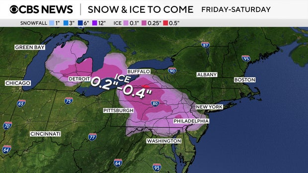
CBS News Detroit reports freezing rain and sleet could make roads extremely treacherous. A winter weather advisory has been issued for Lapeer, Lenawee, Livingston, Macomb, Monroe, Oakland, Washtenaw and Wayne counties.
CBS News Pittsburgh reports most of the the Pittsburgh metro area will only have a brief window for freezing rain before switching over to rain, but portions of central Pennsylvania will get ice accumulation of a quarter-inch or more.
The storm approaches the Philadelphia area Friday afternoon, with CBS News Philadelphia meteorologists advising residents to “Be where you need to be by 3 p.m. on Friday if you can,” and stay off the roads Friday evening and overnight into Saturday.
CBS News Baltimore warns a slick wintry mix of freezing rain and sleet will develop Friday afternoon for parts of central and northern Maryland.
Map shows snow forecast for New York City area
The storm becomes a major snow event for the New York City area from Friday afternoon into Saturday.
CBS News 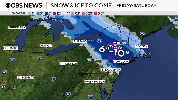
CBS News New York reports snowfall amounts of 4 to 8 inches are forecast for the metro area, while some northern communities could see up to 10 inches, with locally higher amounts possible in the Catskills and Pocono mountains.
It’s expected to be the biggest snowfall the city has seen in nearly four years. The last time NYC got more than 4 inches of snow was Jan. 28-29, 2022, when a strong coastal storm dumped 8.5 inches in Central Park.
Snowfall totals are expected to be slightly lower, 3 to 5 inches, for the Jersey Shore and central New Jersey because of a mix of freezing rain and sleet.
CBS News weather producer Elie Morrison contributed to this report.


